Business Details
34 Years
experience
Expert Land & Hydrographic Surveying Services
Land & Sea Surveying Concepts has been a leader in multi-disciplinary surveying services since 1992. Our team of dedicated professionals combines decades of experience with cutting-edge technology to deliver precise data and actionable insights for client success. Founded by Tim Carlile, a licensed surveyor in six states and a USCG/FAA-certified operator, we maintain state-of-the-art capabilities in land, hydrographic, and aerial drone surveying while prioritizing exceptional customer service. With over 100 years of collective team experience in surveying, ocean engineering, and related fields, we invest continuously in advanced equipment to ensure efficient, accurate results.Our expertise spans boundary surveys, hydrographic mapping, drone-based topography, and specialized projects requiring ROV, sonar, and sub-bottom profiling technologies. This technical depth is complemented by our team's certifications in construction management, marine sciences, and drafting/design, ensuring comprehensive solutions for complex surveying challenges.
Services
Hydrographic Surveying
Land Surveying
Drone Surveying
Subsurface Utility Location
Topographic Mapping
Boundary Surveys
Construction Layout
As-Built Surveys
Bathymetric Mapping
Utility Locates
Details
- Year established: 1992
Highlights and features
- We offer 30+ years of combined surveying expertise with advanced technology integration
- Our team includes FAA-certified drone pilots and USCG-licensed captains
- We maintain specialized expertise in hydrographic, land, and drone surveying methods
- Our veteran-owned status demonstrates commitment to service excellence
- We provide comprehensive solutions from boundary surveys to complex underwater mapping
Services
Hydrographic Surveying
Our hydrographic surveying services utilize multibeam sonar and sub-bottom profilers to map underwater terrain with centimeter-level accuracy. We support dredging operations, port infrastructure, and environmental assessments by creating detailed bathymetric charts and submerged feature documentation. This technology enables precise volume calculations and underwater condition analysis for maritime and coastal projects.
Drone Surveying
Using FAA-certified pilots and advanced drones like the WingtraOne, we capture high-resolution aerial imagery for topographic mapping. Our drone surveys produce geo-referenced orthophotos, 3D models, and NDVI maps covering large areas up to 960 acres in a single flight. This technology provides cost-effective data collection for construction monitoring and land development projects.
Land & Sea Surveying Concepts
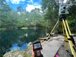
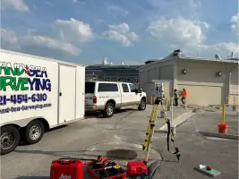
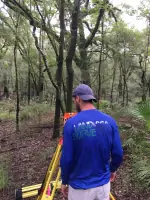
We conduct boundary, topographic, and construction layout surveys using robotic total stations and RTK GPS systems. Our services support property development, infrastructure projects, and legal documentation with precise measurements of surface features and elevation changes. This includes right-of-way mapping and utility infrastructure documentation.
Subsurface Utility Location
Our subsurface utility detection combines ground-penetrating radar and electromagnetic locators to identify buried infrastructure. We provide accurate mapping of underground utilities for construction planning and conflict avoidance, meeting industry standards for damage prevention during excavation projects.
Bathymetric Mapping
We create detailed underwater topographic maps using singlebeam and multibeam sonar systems. These bathymetric surveys support navigation safety, environmental monitoring, and dredging operations by documenting seabed contours and submerged object locations with high spatial resolution.
People
Tim Carlile
Founder and President
Licensed surveyor in six states with 44 years of experience, USCG captain and FAA-certified drone pilot. Developed company's technological capabilities while maintaining hands-on project involvement since founding in 1992.
Suzanne Carlile
Office Manager
Manages accounting and operations with 14 years of corporate finance experience. Certified in multibeam hydrographic systems and CAD software, supporting both administrative and technical aspects of survey projects.
Scott Sharpe
Hydrographic Specialist
25-year ocean engineering expert specializing in marine instrumentation and hydrographic data collection. Oversees complex bathymetric surveys and manages multi-vessel geophysical operations with extensive software expertise.
Michael Carlile
CAD Manager
Geomatics-trained CAD manager with confined space certification. Combines field survey experience with drafting expertise to ensure accurate data translation from field collection to final deliverables.
Timothy Carlile
Lead Survey Technician
Six-year veteran in topographic and hydrographic surveys with certifications in vessel operation and drone piloting. Specializes in robotic total stations and RTK GPS systems for precision field data collection.
Questions
What surveying services does Land & Sea offer?
We provide hydrographic, land, drone, boundary, topographic, bathymetric, construction layout, as-built, subsurface utility, and utility locate services.
How experienced is your team?
Our team has over 100 combined years of experience with specialized expertise in hydrographic systems, marine sciences, and geospatial technologies.
What technology do you use?
We utilize multibeam sonar, drone mapping, RTK GPS, total stations, and advanced software like HYPACK and MicroStation for precise data collection.
Are you certified for government projects?
Yes, we're certified as a Veteran-Owned Small Business and meet federal/state standards for public infrastructure projects.
What geographic areas do you serve?
We operate throughout Florida with capabilities extending to coastal and inland waterways across the southeastern United States.
Reviews (2)
Desiree Webb
Apr 06, 2021
Report
Land and Sea Surveying is professional, precise and speedy. Their experienced friendly staff helped us quickly when needed. Full of helpful information pertaining to all aspects of survey work.
Mel Mel Lorenti
Oct 04, 2018
Report
Wonderful, friendly! Very willing to help me out on a pinch when no other company would. I HIGHLY RECOMMEND! THANKS Suzanne!