Business Details
Professional Land Surveying Services in Fort Wayne, IN
Bertsch-Frank & Associates is a professional land surveying firm dedicated to delivering precise, efficient, and technologically advanced solutions. With over 50 years of combined experience, our team specializes in boundary surveys, topographical mapping, construction engineering, and erosion control planning. Our principals hold degrees from ABET-accredited programs and are actively involved in professional organizations like the American Society of Civil Engineers and the Indiana Society of Professional Land Surveyors.We prioritize safety, accuracy, and community engagement, offering tailored services for industries ranging from highways to healthcare facilities. Our commitment to innovation ensures clients receive reliable data and expert guidance for every project.

Services
Civil/Site Design
Construction Engineering
High Definition Laser Scanning
Land Surveying
Topographical Surveys
Boundary Surveys
Erosion Control Plans
Site Development and Design
Stormwater Management
Transportation Design
Highlights and features
- We have over 50 years of combined land surveying experience.
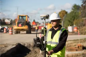
- We utilize the latest GPS and robotic surveying technology.
- Our team holds degrees from ABET-accredited programs.
- Active community involvement in promoting land surveying.
- Members of the American Society of Civil Engineers and Indiana Society of Professional Land Surveyors.
Associations and certifications
- ABET
Services
Land Surveying
Our land surveying services employ GPS and robotic technology to deliver precise boundary, topographical, and construction surveys. We serve residential, commercial, and industrial clients, ensuring compliance with state regulations and project-specific requirements. With decades of combined experience, our team provides accurate data for infrastructure, development, and legal documentation.
Civil/Site Design
We specialize in civil/site design for commercial, industrial, and infrastructure projects. Our services include grading plans, erosion control, and stormwater management. Leveraging advanced software and field data, we create efficient, code-compliant designs tailored to client needs and environmental standards.
Construction Engineering
Our construction engineering services provide layout and coordination for building and infrastructure projects. Using high-definition scanning and robotic tools, we ensure precise alignment and adherence to design specifications. Our team supports contractors with real-time data and problem-solving expertise.
High Definition Laser Scanning
High-definition laser scanning captures detailed 3D models of existing structures and terrain. This technology supports accurate as-built documentation, design validation, and project planning. We use it for complex sites requiring millimeter-level precision, including industrial facilities and transportation infrastructure.
Erosion Control Plans
We develop erosion control and stormwater management plans to mitigate environmental impact. Our solutions include sediment barriers, detention basins, and sustainable drainage systems. These plans ensure compliance with regulatory standards while protecting land and water quality during and after construction.
People
Ross Frank
Principal
Ross Frank began his surveying career in 1995, specializing in residential and commercial surveys. As a principal, he oversees field operations, GPS/robotic surveys, and construction layout. He holds a Bachelor of Science in Construction Engineering Technology from Purdue University and is a licensed Professional Land Surveyor in Indiana.
Matt Bertsch
Principal
Matt Bertsch has over 25 years of surveying experience, focusing on office coordination, boundary surveys, and erosion control plans. He holds a Bachelor of Science in Construction Engineering Technology from Purdue University and is a licensed Professional Land Surveyor in Indiana and Engineering Intern in Ohio.
Nick Bertsch
Principal
Nick Bertsch, a Professional Land Surveyor in Indiana, joined the firm in 2006. He specializes in field surveys, construction engineering, and robotic technology. He earned an Associate of Science in Civil Engineering Technology from Purdue University and leads field crews for complex projects.
Wayne Richardson
Engineering Manager
Wayne Richardson oversees site design, transportation, and stormwater projects. With a Master of Science in Civil Engineering from Purdue University, he is a licensed Professional Engineer in Indiana and Michigan, specializing in sustainable infrastructure solutions.
Questions
What services does Bertsch-Frank & Associates offer?
We provide land surveying, civil/site design, construction engineering, high-definition laser scanning, and erosion control plans for commercial, industrial, and infrastructure projects.
How long has Bertsch-Frank & Associates been in business?
Our team has over 50 years of combined experience, with principals starting their surveying careers in 1995.
What industries do you serve?
We serve highways, education facilities, airports, hospitals, churches, utilities, and alternate energy projects with tailored surveying and engineering solutions.
Are your surveyors licensed and certified?
Yes, our principals are licensed Professional Land Surveyors in Indiana, with degrees from ABET-accredited programs and memberships in professional organizations.