 Martin & Whitacre Surveyors & Engineers, Inc. has been providing quality surveying and engineering services throughout the Midwest since 1982. The company adheres to the philosophy of producing quality work on an ambitious schedule according to the client’s plan and budget. We have earned a reputation for providing service according to the highest level of standards, utilizing the latest in Surveying and Engineering technology.
Follow us
Services
Civil Engineering
Report
We provide professional design services for commercial, municipal/public, industrial and residential projects. Our expertise, experience and diligence leads to quality projects being completed on time and within the proposed budget. Our expertise and flexibility allows us to perform many roles as a design team partner.
Land Surveying
Report
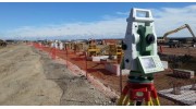 Our licensed professionals utilize the latest in field & office technology to solve all surveying problems, large or small. Equipped with global positioning equipment, digital levels, and robotic total stations our field crews upload & download digital data for processing to AutoCAD or MicroStation platform drawings. Solving complex surveying and measurement problems through today’s technology is our business.
 Laser Scanning
Report
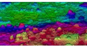
 We offer 3D Laser Scanning to solve complex surveying and engineering problems. With this technology we can capture millions of data points at hard to reach or dangerous locations with 6mm or better accuracy and no safety hazards. The resulting high density point cloud and digital photo images provide a higher confidence in the accuracy and completeness of the survey. This data can be converted to 2D or 3D drawings for mapping and design work. By starting with higher quality field data, clients can expect a better design and reduced construction risk.
 Bathymetric
Report
 Martin & Whitacre utilizes the Odom MB-1 multibeam echo sounder to collect full coverage bathymetric data for dredge operations or channel design. Data can be collected, processed and uploaded to dredge equipment for real time quality control operations.
Reviews

Be the first to review Martin & Whitacre, Surveyors & Engineers.
Write a Review