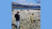
 Statewide is the Pacific Northwest provider of land, habitat restoration, hydrographic and terrestrial surveying services. On land or in the water, Statewide delivers timely, precise results. At Statewide, we deliver the highest quality survey solutions to homeowners, contractors, architects, scientists and engineers in both Oregon and Washington.
We work hard to deliver perfect results and personalized service. Capable of providing both land and bathymetric surveys, Statewide utilizes single-beam sonar, considered to most portable, cost efficient, and the best choice for many surveys.
Follow us
Services
About
Report
A full-service surveying firm, Statewide is capable of providing both land and bathymetric surveys across the Pacific Northwest. At Statewide, we thrive on providing price-competitive quality work across survey disciplines, with an emphasis on safety and shared team knowledge and experience. We maintain consistent project and quality standards that are unparalleled and have been integral to continuing client referrals and repeat customers. Our goal is always to provide customers with project results that are on time, on budget and delivered to meet or exceed specific goals and needs.
Services
Report
At Statewide, we deliver superior solutions for all your surveying needs. Whether it's as simple as determining a property line or as complex as staking a new hospital, Statewide offers a comprehensive list of services for every situation. The following list provides a general outline of the services provided by Statewide - you'll find a detailed description of what we do and a sample. If you are interested in working together, send us an inquiry and we will get back to you as soon as we can!
To Upload Files
Report
Construction Surveys
Report
The process of establishing and marking the position and detailed layout of new structures such as roads and buildings for subsequent construction. Construction staking data provides horizontal and vertical information necessary for surface drains or pipe flow for most urban, rural and suburban settings.
Reviews

Be the first to review Statewide Land Surveying.
Write a Review