
Business Details
50+ Years
experience
Your Trusted Land Surveying Partner in Ashland, WI
Nelson Surveying has been a trusted name in professional land surveying since 1954. Founded by Thomas W. Nelson, our firm has evolved through three generations of family leadership while maintaining a commitment to precision and integrity. We combine decades of expertise with cutting-edge GPS technology to deliver accurate, reliable data for boundary surveys, floodplain assessments, and construction projects. Our extensive historical records dating back to the 1890s complement modern methodologies, ensuring clients receive comprehensive solutions tailored to Northern Wisconsin's unique terrain. With offices in Ashland, we serve Ashland, Bayfield, Iron, Douglas, Price, and Sawyer counties, collaborating closely with real estate professionals, attorneys, and government agencies.Our reputation for timely execution and regulatory compliance has made us a preferred partner for over 70 years. The third-generation ownership transition in 2017 solidified our dedication to preserving foundational values while embracing technological advancements. Our team's deep local knowledge and established relationships with zoning departments streamline project approvals. We pride ourselves on maintaining the highest standards of accuracy recognized by industry peers and clients across diverse sectors. From initial consultations to final deliverables, Nelson Surveying remains committed to exceeding expectations through transparent communication and meticulous attention to detail.

Services
Boundary Surveys
Floodplain Surveys
Land Use Planning
Construction Staking
Details
- Year established: 1954
Highlights and features
- We offer over 70 years of experience in professional land surveying
- Our family-owned business maintains generational expertise and integrity
- We utilize cutting-edge GPS systems for unparalleled accuracy
- Our historical records date back to the 1890s for comprehensive analysis
- We maintain strong working relationships with local government agencies
What people say
Highest level of accuracy
Timely manner
Highly respected
Competent services
Valuable resource
Services
Boundary Surveys
Our boundary surveys establish precise property lines using historical records and modern GPS technology. This service supports real estate transactions, development projects, and legal dispute resolution. Clients receive detailed documentation compliant with Wisconsin statutes and local ordinances.
Floodplain Surveys
Floodplain surveys determine elevation data and flood risk zones for regulatory compliance. We provide FEMA-certified certificates and mitigation recommendations. This service supports building permits and insurance requirements in Northern Wisconsin's water-adjacent properties.
Land Use Planning
Our land use planning integrates topographical data with zoning regulations for development projects. We collaborate with municipalities to ensure compliance with environmental protections and infrastructure requirements. This service streamlines approvals for residential and commercial developments.
Construction Staking
Construction staking translates architectural plans into physical markers for accurate building placement. We use robotic total stations for precision in grading, utilities, and foundation layout. This service minimizes costly errors during project execution.
People
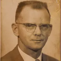
Thomas W. Nelson
Founder
Founded Nelson Surveying in 1954 after WWII service. Established foundational principles of accuracy and integrity while pioneering early surveying techniques in Northern Wisconsin.
Larry T. Nelson
Former Owner
Expanded service areas and integrated GPS technology during 35 years of leadership. Developed the High Accuracy Reference Network (HARN) system still used in modern surveying practices.
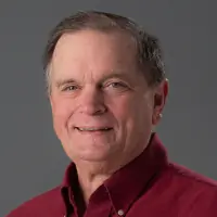
Peter A. Nelson
Current Owner
Third-generation owner since 2017 with 20+ years experience. Maintains family legacy while advancing federal surveying certifications and digital data management systems.
Lon
Crew Chief
Lead field technician with 20+ years experience managing survey crews and complex project execution across Northern Wisconsin's challenging terrain.
Questions
What surveying services do you specialize in?
We specialize in boundary surveys, floodplain assessments, land use planning, and construction staking for residential, commercial, and legal applications.
How far do your service areas extend?
We primarily serve Northern Wisconsin counties including Ashland, Bayfield, Iron, Douglas, Price, and Sawyer.
Can you assist with federal survey requirements?
Yes, our team includes Certified Federal Surveyors qualified to handle projects requiring national standard compliance.
Do you work with other professionals on development projects?
We regularly collaborate with attorneys, real estate agents, engineers, and government agencies to ensure comprehensive project completion.
How do I request a free estimate?
Contact us via phone at 715-682-2692 or through our website contact form to receive a no-obligation project estimate.
Reviews (1)
Michael Murphy
Jun 26, 2021
Report
Had them survey one mile of heavy timber land and the two young men did it great in the canyons south of Lake Superior 2017.