Business Details
33 Years
experience
Your Trusted Land Surveyors in Monterey, CA
Central Coast Surveyors has been a trusted provider of professional land surveying and mapping services in Monterey County since 1993. With over 35 years of combined experience, our team delivers precision and efficiency across diverse projects ranging from residential topographic maps to large-scale commercial developments. We specialize in topographic surveys, boundary surveys, ALTA/NSPS land title surveys, construction staking, GPS surveys, and FEMA elevation certificates.Our expertise extends to supporting engineering, architecture, environmental, telecommunications, real estate, and public agency sectors. Licensed in California and Hawaii, we pride ourselves on rapid turnaround times, clear communication, and tailored solutions for every client. Our commitment to excellence has made us the surveying partner of choice for projects including hospitals, retail centers, and infrastructure developments across the Monterey Bay area and beyond.
Services
Topographic Surveys
Construction Surveys
ALTA/NSPS Land Title Surveys
Boundary Surveys
FEMA Elevation Certificates
Details
- Year established: 1993
Highlights and features
- We offer over 35 years of land surveying experience since 1993
- Our team delivers rapid turnaround times for all surveying projects
- Licensed professionals operating in both California and Hawaii
- We serve diverse industries including real estate, engineering, and public agencies
- Specialized expertise in ALTA/NSPS land title surveys and FEMA elevation certificates
Services
Topographic Surveys
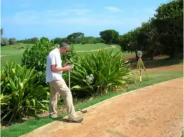
Our topographic surveys create detailed elevation models for land development projects. Using advanced GPS technology, we map natural and man-made features to support engineering and construction planning. Clients receive accurate digital terrain models and contour maps for site analysis.
ALTA/NSPS Surveys
We conduct ALTA/NSPS land title surveys meeting strict industry standards for commercial property transactions. These comprehensive boundary surveys include easement verification, encroachment checks, and title company requirements. Our surveys ensure clear property documentation for lenders and title insurers.
Boundary Surveys
Our boundary surveys establish precise property lines using historical records and field measurements. We identify existing monuments, resolve boundary disputes, and provide legal documentation for fencing, landscaping, or development projects across residential and commercial properties.
Construction Surveys
We provide construction staking services for accurate building layout and infrastructure placement. Our team marks critical points for foundations, utilities, and grading to ensure compliance with architectural plans and municipal regulations during development projects.
FEMA Certificates
Our FEMA elevation certificates determine flood risk for properties in Special Flood Hazard Areas. We measure lowest floor elevations and compare them to base flood levels, helping property owners meet insurance requirements and potentially reduce flood insurance premiums through accurate documentation.
Questions
What surveying services do you offer?
We provide topographic surveys, boundary surveys, ALTA/NSPS land title surveys, construction staking, GPS surveys, and FEMA elevation certificates for residential and commercial clients.
How long have you been in business?
Central Coast Surveyors has served Monterey County and surrounding areas since 1993, with over 35 years of combined experience in land surveying and mapping.
Do you operate outside Monterey County?
Yes, we serve the entire Monterey Bay area, Hollister, Santa Cruz, and have completed projects in Hawaii through our dual licensing in California and Hawaii.
What industries do you work with?
Our clients include engineering firms, architects, environmental consultants, telecommunications companies, real estate developers, homeowners, and public agencies across California and Hawaii.
Are you licensed professionals?
Yes, we hold active California license #LS4974 and Hawaii license #LS11860, ensuring all surveying work meets state regulatory standards and professional requirements.
What is a FEMA elevation certificate?
A FEMA elevation certificate verifies property elevations relative to floodplain levels, determining flood insurance requirements for properties in Special Flood Hazard Areas.