
Business Details
50+ Years
experience
Professional Surveying, Civil Engineering & 3D Scanning Services in Glendale, CA
Since 1924, Mollenhauer Group has been a trusted leader in surveying, civil engineering, and 3D scanning services across Southern California. Our firm combines nearly a century of experience with cutting-edge technology to deliver precise, innovative solutions for commercial, residential, and industrial projects. We specialize in land surveying, civil engineering design, and Building Information Modeling (BIM), serving government agencies, developers, architects, and educational institutions. Our team of licensed professionals maintains a steadfast commitment to technical excellence, ethical practices, and client satisfaction. With headquarters in Glendale, we have completed thousands of projects demonstrating our ability to handle complex challenges with accuracy and efficiency.Our long-tenured staff brings deep expertise in ALTA surveys, ADA compliance, utility detection, and high-rise construction surveys. We invest continuously in state-of-the-art equipment like Faro Focus 3D scanners to ensure superior data collection and modeling capabilities. Our reputation for reliability and quality has been built through decades of repeat clients and successful partnerships with major institutions like the Los Angeles Unified School District. We approach every project with personalized attention, maintaining direct involvement from project managers throughout each phase. This dedication to service has established us as one of the region's most respected firms in our field.
Services
Land Surveying
Civil Engineering
3D Laser Scanning
Building Information Modeling
ALTA Surveys
Topographic Surveys
Utility Detection
ADA Compliance
Construction Surveying
Subdivision Mapping
Details
- Year established: 1924
Highlights and features
- We have 99 years of continuous experience in Southern California's land development industry
- Our team includes registered professional engineers and land surveyors with decades of tenure
- We utilize state-of-the-art Faro Focus 3D scanning technology for accurate modeling
- We maintain direct project manager involvement from concept to completion
- We have completed thousands of projects for major institutions like LAUSD
What people say
Quality deliverables
Timely manner
Unparalleled expertise
Accurate and timely
Innovative solutions
Services
Land Surveying
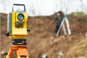
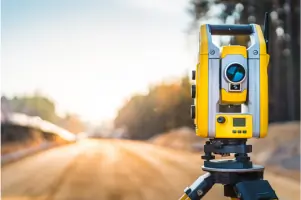
Our land surveying services provide precise boundary determinations and topographic mapping for commercial and residential developments. Using GPS and 3D scanning technology, we deliver ALTA/ACSM surveys, utility detection, and construction staking with exceptional accuracy. Our experienced surveyors support projects ranging from small residential lots to large-scale urban developments.
Civil Engineering
We offer comprehensive civil engineering solutions including site development, drainage systems, and infrastructure design. Our engineers create grading plans, stormwater management systems, and utility designs that meet all regulatory requirements. With expertise in LEED certification and ADA compliance, we support educational, commercial, and industrial clients throughout Southern California.
3D Laser Scanning
Our 3D laser scanning captures detailed as-built conditions for building information modeling. Using Faro Focus scanners, we create precise point cloud data for architectural renovations and structural analysis. This technology enables efficient Scan-to-BIM workflows that improve project accuracy and reduce rework for complex building systems.
Building Information Modeling
We convert laser scan data into intelligent 3D BIM models using Revit software. Our BIM services support architects, contractors, and facility managers with accurate digital representations of existing structures. This technology enhances coordination between mechanical, electrical, and structural systems during renovation projects across various building types.
ADA Compliance
Our ADA compliance services ensure facilities meet federal accessibility standards through detailed path-of-travel assessments. We create accessible route plans and design modifications for educational institutions and public buildings. Our engineers have extensive experience implementing ADA requirements in both new construction and renovation projects for school districts across Southern California.
People
Gregory D. Hindson
Principal Professional Land Surveyor
With decades of experience, Gregory D. Hindson leads surveying operations with expertise in boundary determination and construction staking. He ensures technical excellence across all surveying projects.
Thomas Tran
Senior Vice-President Professional Civil Engineer
Thomas Tran oversees civil engineering projects with 25+ years of experience in site development and infrastructure design. He specializes in regulatory compliance and utility coordination for complex developments.
Rick Harris
Innovation/Technology Manager
Rick Harris directs technology implementation, specializing in 3D scanning and BIM workflows. He has advanced expertise in converting point cloud data into actionable engineering models for renovation projects.
Questions
What surveying services do you offer?
We provide ALTA/ACSM surveys, topographic mapping, utility detection, construction staking, and boundary surveys using GPS and 3D scanning technology.
Do you handle civil engineering for educational facilities?
Yes, we specialize in school projects including ADA compliance, site development, and infrastructure design for districts like LAUSD and SVUSD.
What technology do you use for 3D modeling?
We use Faro Focus 3D scanners and Revit software to create accurate point cloud data and Building Information Models for renovations.
How long have you served Southern California?
We've provided surveying and engineering services continuously since 1924, with deep knowledge of local regulations and conditions.
What makes your firm different?
Our combination of 99-year experience, registered professionals, and investment in cutting-edge technology ensures superior project outcomes.