Business Details
39 Years
experience
Your Trusted Land Surveying Partner in Charleston, SC
Established in 1987, GPA Professional Land Surveyors has built a reputation for excellence and integrity in serving clients across North and South Carolina. Our team of licensed professionals combines advanced technology with decades of experience to deliver accurate, reliable land surveying solutions tailored to each client's unique needs. We prioritize personalized service, treating every client as our sole focus while leveraging cutting-edge tools like GPS and Autodesk software to ensure precision.Our commitment to meeting deadlines without compromising quality has made us a trusted partner for real estate professionals, engineers, architects, and developers. With offices strategically located to maximize efficiency, we streamline complex projects from design to completion, ensuring timely, cost-effective results that exceed expectations.

Services
Boundary Surveys
ALTA/NSPS Surveys
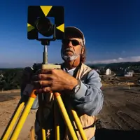
Construction Staking
Topographic Surveys
As-Built Surveys
Route Surveys
Geodetic Control Projects
Flood Certifications
DEHC Approvals
Minor Subdivisions
Details
- Year established: 1987
Highlights and features
- We treat each client as our only client.
- Our staff holds degrees in land surveying and civil engineering.
- Licensed in North and South Carolina.
- Deadline-driven to meet client demands.
- Utilize the latest land development software.
Services
Boundary Surveys
Our boundary surveys precisely define property lines using advanced GPS technology and historical deed research. We deliver ALTA/NSPS-compliant reports for real estate transactions, legal disputes, and development projects. Clients benefit from our expertise in resolving complex boundary retracement challenges across North and South Carolina.
Construction Staking
We provide accurate construction staking for residential, commercial, and infrastructure projects. Our teams use robotic instruments and GPS to mark building control points, drainage systems, and road alignments. This ensures proper grading and compliance with municipal requirements throughout the Carolinas.
Topographic Surveys
Our topographic surveys capture detailed elevation data and natural features using photogrammetry and field measurements. Engineers and architects rely on these maps for site planning, floodplain analysis, and environmental assessments. We integrate GIS/LIS systems for comprehensive land management solutions.
As-Built Surveys
We document completed construction projects through as-built surveys, verifying alignment with original plans. Our services include sewer, drainage, and steel structure verification. These records ensure compliance with local regulations and support future maintenance operations for developers and municipalities.
ALTA/NSPS Surveys
Our ALTA/NSPS-compliant surveys meet national standards for commercial real estate transactions. We identify easements, encroachments, and boundary improvements while adhering to title insurance requirements. Attorneys and lenders trust our detailed reports to mitigate legal risks in property acquisitions.
Questions
What geographic areas do you serve?
We provide land surveying services throughout North and South Carolina, with offices strategically located in Charleston, Charlotte, Fort Mill, and Raleigh.
What technologies do you use?
We utilize GPS, robotic instruments, Autodesk and Carlson software, and photogrammetry to ensure precise data collection and mapping for all project types.
How do you handle urgent projects?
Our deadline-driven approach prioritizes timely delivery without compromising accuracy, with field crews dedicated to meeting client schedules for critical projects.
What industries do you work with?
We serve real estate professionals, engineers, architects, general contractors, and land developers with customized surveying solutions for residential, commercial, and infrastructure projects.
How can I request services?
Contact our Charleston corporate office at 843.285.2424 or visit our website to discuss your project requirements with our surveying experts.