
Business Details
38 Years
experience
Professional Land Surveying Services in Denison, TX
Established in 1988, our family-owned business has built a reputation for precision and integrity in land surveying. We combine decades of hands-on experience with cutting-edge technology to deliver accurate results for residential, commercial, and industrial clients. Our team prioritizes client education, ensuring every customer understands their project's scope and requirements. Headquartered in Denison, Texas, we serve North Texas and Southern Oklahoma with a commitment to ethical practices and technical excellence. Our licensed professionals hold certifications in multiple surveying disciplines, reflecting our dedication to industry standards. We maintain full insurance coverage and professional liability protection to safeguard client investments.Through personalized service and a focus on necessity-driven solutions, we've cultivated lasting relationships with homeowners, builders, and developers. Our strategic approach integrates innovation while preserving the personal touch that defines our family-operated roots. From boundary determination to construction staking, we provide comprehensive services tailored to each project's unique demands. Backed by 35+ years of regional expertise, we continue to expand our capabilities while upholding the core values that have guided us since inception.
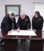
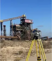
Services
Drone Surveys
Boundary Surveys
Topographic Mapping
Construction Staking
ALTA/NSPS Surveys
Elevation Certificates
Photogrammetry
LiDAR Scanning
Details
- Year established: 1988
Highlights and features
- Family-owned with 35+ years of regional surveying expertise
- Fully licensed and insured with professional liability coverage
- Utilize drone technology and LiDAR for precise measurements
- Provide clear, necessity-driven solutions without upselling
- Serve both residential and commercial clients across two states
Associations and certifications
- TBPLS Firm No. 10006300
- Oklahoma CA No. 2315
Services
Boundary Surveys
Our boundary surveys precisely determine property lines using advanced technology and historical records. This service ensures compliance with local regulations while protecting property investments. Clients receive detailed documentation crucial for construction, development, or resolving property disputes.
Topographic Mapping
We create detailed topographic maps showing natural and man-made land features with elevation data. These surveys support landscape design, construction planning, and environmental assessments by providing accurate site analysis for engineers and architects.
Construction Staking
Our construction staking services mark exact locations for buildings, roads, and infrastructure according to design plans. This ensures proper alignment and elevations during construction, guiding crews through complex development projects with precision.
Drone Surveys
Using drone technology, we capture high-resolution aerial imagery and LiDAR data for comprehensive land analysis. This method provides efficient, accurate mapping for large areas, supporting various applications from site planning to topographic modeling.
ALTA/NSPS Surveys
We conduct ALTA/NSPS standard surveys meeting strict requirements for property transactions. These comprehensive surveys identify boundaries, easements, and improvements to minimize ownership risks, providing essential documentation for lenders and property buyers.
People
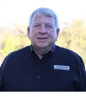
Doug Underwood
Owner and President
Licensed surveyor with 40+ years experience, founded the company in 1988 after starting his career in 1977. Holds Texas and Oklahoma licenses and multiple survey certifications.
Brett
Surveyor in Training
Full-time surveyor since 2008 with SIT certification. Manages field operations and client communications while maintaining Texas Notary Public status.
John
Project Manager
Experienced draftsman with 30+ years in surveying. Specializes in construction staking for major industrial projects including semiconductor manufacturing facilities and commercial developments.
Rhonda
Research Coordinator
Responsible for land records research since 2018. Collaborates with government agencies to uncover historical property information critical for survey accuracy.
Kim
Office Manager
Manages office operations and client communications with 20+ years of experience. Handles financial coordination with title companies and lending institutions.
Questions
What areas do you serve?
We provide land surveying services throughout North Texas and Southern Oklahoma from our Denison, Texas headquarters.
Are you licensed and insured?
Yes, we maintain full licensing through Texas and Oklahoma boards along with professional liability insurance coverage.
What survey technologies do you use?
We employ drone technology, LiDAR scanning, and photogrammetry alongside traditional surveying methods for maximum accuracy.
Do you handle both residential and commercial projects?
Yes, we serve homeowners needing boundary determination as well as commercial developers requiring complex construction staking.
How do I request a quote?
Contact us through our website form or call 903-465-2151 to discuss your project details and receive a customized quote.
What's your experience with industrial projects?
Our team has completed surveys for major industrial expansions including semiconductor manufacturing facilities and global wafer production plants.
Reviews (3)
Tracy Taylor
Jan 05, 2021
Report
I was actually across the street where acquaintnance of mine operates his own business. He used to work for Underwood Drafting & Surveying, Inc.
Lee Ditto
Dec 26, 2020
Report
They were surveying a property a block over from me and came through my yard, dug holes in my yard, and left without filling in the holes. When I called and spoke to the owner to complain about his employees coming into my property without permission, digging up my grass and leaving holes, he tries to tell me that I don't own my front yard. He says his people have the right walk across my yard and dig holes.
Dave N.
Apr 27, 2020
Report
Definitely Cannot Recommend They Never completed my home purchase survey. After they surveyed there were 2 pieces of ribbon on 1 fence on 1 side of property, 1 side of a square does not a survey make. Contacted multiple times since and never get past secretary who I guess round files my calls. Definitely Cannot Recommend