
Business Details
Expert Geospatial Surveying Solutions in Marlette, MI
Muxlow Surveying is an experienced small business dedicated to delivering precise geospatial surveying and mapping solutions for local boundaries, transportation, energy, and federal projects across Michigan and the Great Lakes Region. As a Woman-Owned Small Business (WOSB) and MDOT DBE-certified firm, we combine technical expertise with a commitment to quality, serving clients ranging from local residents to Fortune 500 companies and government agencies.Our team leverages advanced technologies like UAV mapping, mobile LiDAR, and hydrographic surveys to address complex challenges while adhering to rigorous industry standards. Beyond our core services, we actively engage in humanitarian aid and social projects, reflecting our dedication to community impact. Licensed surveyors across six states, we prioritize collaboration, innovation, and client satisfaction in every project.
Services
Boundary Surveys
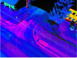
Mobile LiDAR Mapping
Hydrographic Surveys
UAV Mapping
ALTA Surveys
Legal Descriptions
Road Design Surveys
Easement Creation
Topographic Surveys
Consulting Services
Highlights and features
- We are MDOT DBE and WOSB certified for state and federal projects.
- Licensed surveyors in six states across the Great Lakes Region.
- Specialize in advanced technologies like UAV mapping and LiDAR.
- Serve diverse clients from government agencies to Fortune 500 firms.
- Committed to humanitarian aid and community-focused initiatives.
Associations and certifications
- MDOT DBE
- WOSB
- ASPRS
What people say
Great work again
Exceptional service quality
Precision in surveys
Professional team
Hats off to staff
Services
Boundary Surveys
Boundary Surveys establish property lines and corners using precise measurements. We provide detailed mapping and legal descriptions for residential, commercial, and government clients. Our expertise ensures compliance with local regulations and accurate land division.
Mobile LiDAR Mapping
Mobile LiDAR Mapping captures high-resolution 3D data for infrastructure and terrain analysis. This technology enables rapid data collection for road design, asset management, and environmental monitoring with millimeter-level accuracy.
Hydrographic Surveys
Hydrographic Surveys map underwater terrain using manned and unmanned vessels. We assess lakebeds, rivers, and coastal areas for erosion, navigation safety, and environmental studies, supporting federal and state agencies.
UAV Mapping
UAV Mapping utilizes drones for aerial photogrammetry and topographic data collection. This method provides cost-effective, high-resolution imagery for large-scale projects like energy sites and transportation corridors.
ALTA Surveys
ALTA Surveys meet national standards for property transactions, detailing boundaries, easements, and improvements. These surveys are essential for commercial real estate deals, ensuring legal clarity and minimizing disputes.
People
Tricia Muxlow
President | CEO
Tricia Muxlow leads Muxlow Surveying with over 20 years of experience in geospatial services. She specializes in federal and state surveying projects, emphasizing technical precision and client collaboration.
Roberta Hardy
Office Manager | Project Coordinator
Roberta Hardy oversees daily operations and project coordination, ensuring seamless client communication and efficient project delivery. Her organizational expertise supports the firm's growth and client satisfaction.
Ron Meyer
Senior Crew Chief
Ron Meyer, a Certified Survey Technician (Level IV), leads field operations with expertise in LiDAR, GPS, and topographic surveys. His technical skills ensure high-quality data collection across complex projects.
Questions
What services does Muxlow Surveying offer?
We provide boundary surveys, LiDAR mapping, UAV surveys, hydrographic studies, ALTA surveys, and legal descriptions for residential, commercial, and federal clients.
Which areas do you serve?
We operate primarily in Michigan and the Great Lakes Region, with licensed surveyors in six states and nationwide partnerships.
Are you certified for state and federal projects?
Yes, we are MDOT DBE-certified, Woman-Owned Small Business (WOSB) verified, and prequalified for Michigan transportation projects.
How do you ensure survey accuracy?
We use advanced tools like LiDAR, UAVs, and GPS, combined with licensed professionals and rigorous quality control processes.