Business Details
50+ Years
experience
Your Trusted Partner for Land Surveying & Civil Engineering in Red Wing, MN
Founded in 1972, Johnson & Scofield has grown from a single office in Red Wing to serve Minnesota and Wisconsin with four locations. Our team of licensed professionals specializes in land surveying and civil engineering, combining technical expertise with personalized service. We deliver boundary surveys, topographic mapping, flood certifications, and infrastructure design while maintaining a small-town commitment to client relationships. With decades of collective experience, we provide precise data and actionable solutions for residential, commercial, and municipal projects.Our history of innovation began with the Harry S. Johnson Companies and continues through our four offices in Red Wing, Hastings, Wabasha, and Winona. We prioritize clear communication, using advanced technology to meet modern engineering challenges while honoring traditional values of integrity and accountability. From property line determinations to complex civil infrastructure projects, our work ensures clients receive accurate, legally defensible results tailored to their specific needs.

Services
Land Surveying
Civil Engineering
Boundary Surveys
Topographic Surveys
Flood Surveys
Subdivision Platting
ALTA/ACSM Surveys
Construction Staking
As-Built Surveys
Details
- Year established: 1972
Highlights and features
- We offer 50+ years of combined experience in land surveying and civil engineering
- Our team provides personalized service with licensed professionals at all four Minnesota locations
- We deliver comprehensive solutions from boundary surveys to infrastructure design
- Our work combines advanced technology with legally defensible documentation
- We maintain small-town service values while meeting complex modern engineering demands
Services
Land Surveying
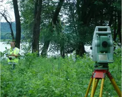
Our land surveying services establish precise property boundaries using iron monuments and visible markers. We document encroachments and create legal descriptions for real estate transactions. Clients receive detailed Certificate of Survey drawings signed by licensed professionals, essential for property disputes, construction projects, and title insurance requirements.
Civil Engineering
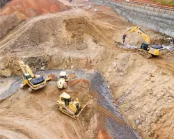
We design roads, water systems, and drainage infrastructure with hydraulic analysis. Our engineers create construction drawings and manage project specifications. Services include on-site inspections, material testing oversight, and contract compliance certification to ensure quality throughout the construction process.
Boundary Surveys
Boundary surveys determine exact parcel dimensions through historical research and field measurements. We place iron monuments and visible markers at corners while documenting encroachments. These surveys protect property rights, resolve disputes, and provide legal documentation for real estate transactions and development projects.
Flood Surveys
Flood elevation certificates document structure elevations relative to FEMA flood zones. We prepare documentation for LOMA requests to remove properties from flood maps. Our surveys help clients avoid unnecessary flood insurance premiums by proving structures meet or exceed base flood elevation requirements.
Topographic Surveys
Topographic surveys map elevation contours and physical features using field data. We create detailed site plans showing buildings, utilities, and natural features. These surveys support construction planning, drainage analysis, and site development projects with accurate elevation information.
People
Marcus Johnson
Office Manager
Licensed surveyor managing Red Wing operations with 20+ years of boundary survey expertise. Specializes in property dispute resolution and legal documentation.
Scott Bechel
Office Manager
Licensed Wisconsin surveyor overseeing Wabasha office. Focuses on flood elevation certifications and FEMA map amendments for property owners.
Mitch Scofield
Office Manager
Licensed surveyor managing Hastings location. Expertise in subdivision platting and municipal infrastructure projects across southern Minnesota.
Brian Wodele
Office Manager
Licensed surveyor leading Winona office operations. Specializes in as-built surveys and construction staking for commercial developments.
Questions
When do I need a land survey?
You need a land survey when buying/selling property, building near property lines, resolving boundary disputes, or applying for flood insurance. Lenders often require surveys for mortgage loans.
What civil engineering services do you offer?
We provide construction drawings, road design, water/sewer systems, grading plans, and hydraulic analysis. Our services cover infrastructure projects from initial design to construction oversight.
How do flood elevation certificates help property owners?
Flood elevation certificates document structure elevations to determine flood zone status. They can remove properties from flood maps or establish accurate insurance premiums based on actual risk.
What areas do you serve?
We serve Minnesota and Wisconsin from four offices in Red Wing, Hastings, Wabasha, and Winona. Our teams cover both rural and urban projects across the Upper Midwest.
How are boundary surveys conducted?
Boundary surveys combine historical research with field measurements. We place iron monuments at corners, install visible markers, and document findings in legal certificates signed by licensed professionals.
Reviews (2)
Jim Bono
Mar 10, 2022
Report
Great customer service, excellent communication, timely response to the job. Definitely would recommend Wabasha location!
Ls W.
Apr 28, 2017
Report
We do NOT recommend this company. They did not inform us that they were planning to come onto our private property. When they showed up they did not let us know they were here. They admitted they should have come talk to us to let us know they had come and what they were going to do but they didn't even try.